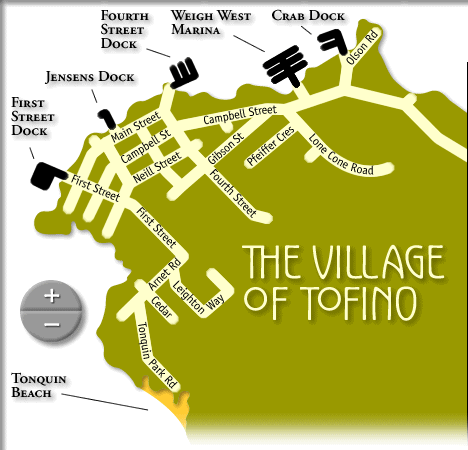
Tofino map of the Village of Tofino
village of tofino map | beaches of tofino map
tofino-long beach-ucluelet map | vancouver island map
 Most visitors to Tofino & Clayoquot Sound arrive by car, bus or plane.
Options for air travel include scheduled service and charters from Vancouver, Victoria and Seattle. Flight time is approximately 50 minutes from Vancouver International Airport, and shuttle bus and taxi service is available from the Tofino Long Beach Airport.
To reach Tofino by car, travel to Vancouver Island via ferry service from Vancouver (Horseshoe Bay just North of Vancouver and Tsawassen just to the South), Seattle or the Sunshine Coast.
Travel North from Nanaimo on Highway 19 for 43 km (26 miles), take Exit 60 onto Highway 4 West, also known as the Pacific Rim Highway, 156 km (97 miles) through spectacular Cathedral Grove, historic Port Alberni, and around beautiful Sproat and Kennedy Lakes.
Travel westward until you come to the junction between Tofino and Ucluelet. Take a right turn leading you north through the Pacific Rim National Park toward Tofino, now only 28 km (17 miles) away.
visit google maps for a satellite photo of Tofino
village of tofino map | beaches of tofino map (esowista peninsula)
tofino-long beach-ucluelet map | vancouver island map
tofino | tofinotime | activities | accommodation | events | directory
maps | travel | dining | art & artists | photos | horoscope | tides
search | info | magazines | articles | advertising | contact
us
hosted in Tofino, Canada by tofino.net & studio tofino
Tofino Map: Map of the Village of Tofino on the Esowista Peninsula, with street names. Location of First Street dock, Jensens dock, Fourth Street dock and Crab dock.
